As we have already
found the Indian population central to the north branch Chicago River at Forest
Glen, we now find a still larger center of Indian life, surrounding the well
known tumuli accredited to the ancient mound builders, by taking into account
all the Indian villages north of the portage river and north and west of the
Lyons Indian village No. 10.
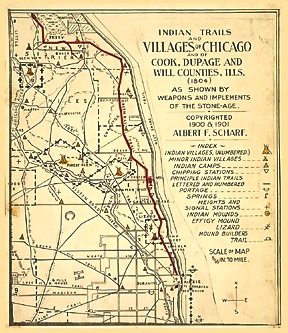
These mounds are part of Indian village No. 4 which lies between two parallel
branches I and G of the mound builders trail, running west from the mouth of
portage river. Then again the DesPlaines River was navigable to this point for
canoes and finally a portage from here to Chicago River was only eight miles.
This was one of half a dozen Indian villages strung along the east bank of
twenty miles of the serpentine DesPlaines, distributing its water to the rising
and setting of the sun.
Indian village No. 4 was located on the east bank in a bend of the DesPlaines
River forming the letter S and covering the whole southeast quarter Sec. 35 town
Leyden. East of the river and the public road, 130 yards north of North Avenue
extended, are the mounds, consisting of a close group of five separate mounds
each with a diameter of from ten to twenty five feet, and three feet high. The
group has a monumental aspect, upon a forty foot high river bank of yellow clay
now covered with a second growth of timber. The view is uninterrupted over the
river and several miles of prairie with the mound builders trail in the
distance.
We will now show that the several places of our original inhabitants were
located with referance to the portage river continued with the West Shore trail.
Vis: from Lake View to Lyons and from Lake View to Glen View, the distance in
each case being about 12 miles. From Lake View to Forest Glen is 6 miles and
from Lyons to Kennicott Mounds is also 6 miles, the last two having canoe
communication from below, but here the similarity ends, Kennicott Mounds having
the most ancient sign of occupancy, a group of Indian mounds, six miles north of
which, at Park Ridge there is another group of three mounds likewise supplied
with a canoe path.
There was a group of two mounds half a mile south of the principle mound
builders trail I, at Harlem. And one mound and several minor burials half a mile
north of the same trail at Thatcher and Chicago Avenues. The Riverside-Lyons
mounds were more of an Indian cemetery and not considered as of mound builders
origin.
This leaves Indian village No. 4, as indicated above, the center of all the
mound builders operations, adjacent and north of the portage river, which place
was also supplied with lateral branches of the Green Bay Trail. The ground
covered by this Indian village proper is a bench or shelf of the river bank
semi-encircled by a spring brook and to-day known as the "Trapp farm," has been
a veritable storehouse of weapons and implements of the Stone Age.
The variety and quality of stone, flint and chert used being merely a
repetition of the other villages with the exception that at the Chicago river
there was more chert from Lake Michigan and here more of a bluish-white chert
from quarries in the interior. The chipping station of course can be located but
the supply of pottery is not extraordinary. The meadows here would furnish
grazing for Indian ponies even in a dry season.
Editor's note: 100 years later, Cazenovia is a part of Franklin Park, Turner Park is River Grove, and Orson is Elmwood Park. Town Leyden is Leyden Township.
Originally transcribed by:
ADENA 2722 Isabella, Evanston, Illinois 60201
epler@adena.com