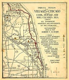

Waubansee, the Pottawatomie chief of whom Chief Alexander Robinson said "he had a voice like a lion," used this trail while camping at Cazanovia 1833 to 1835. Two camps belong to this village, one in the southeast quarter Sec. 15, (Schiller Park) the other in the southwest quarter Sec. 26 (Turner Park) town Leyden.
A war-dance, after the Fort Dearborn Massacre of 1812, held by the Indians in the southwest quarter section 10, town Leyden, on the Alexander Robinson Reservation, on the west bank DesPlaines River in the bend there, was a grand barbacue at the expence of the chief which lasted several days as related by Mrs. Mary Ragor, "Munyon," the chief's (ed: Robinson's) daughter.
The Indian camp where the Grand Avenue trail crossed the Union Ridge, was at Ridgeland Avenue and the Bloomingdale road from where a local trail ran to Indian village number four to which it belonged, being their signal camp on the east. -- -- Capt. William H. Gale, among other stone weapons discovering here the sentry's battle ax.
The Indian camp on Milwaukee Avenue northwest of Irving Park Avenue was an advance from Forest Glen, the same as the one at Addison Street imediately west of the Chicago River (already mentioned) was from Bowmanville. This shows the close connection of the several villages of the Chicago and DesPlaines Rivers camp; the control they had over the Chicago plateau lying between these two rivers.
And now we come to what must have been the Indian signal camp in the center of communication no matter what the distance or direction, located on the Grand Avenue trail three miles west of the lake -- one block west of Western Avenue and Indiana Street -- A natural mound, nearly equi-distant from the Chicago river in three directions north, south and east.
The stone quarry sunk here in early times having destroyed all record of this place, no precise account can be given. Still the sweeping view had here was for miles in every direction even to the Chicago River as is well remembered by many of our early settlers.
Editor's note: 100 years later, Cazenovia is part of Franklin Park, Turner Park is River Grove, and Orson is Elmwood Park. Town Leyden is Leyden Township.
Originally transcribed by:
ADENA 2722 Isabella, Evanston, Illinois 60201
epler@adena.com